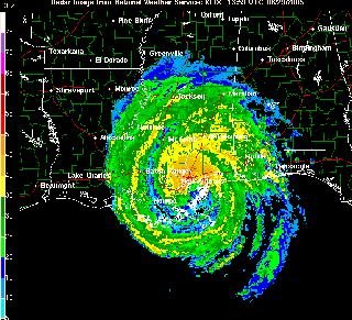
Monday, August 29, 2005

KATRINA DELIVERS...SEAFOOD...?
Driving back into the office tonight, I found this little creature running around in the driveway....

It was about 12 inches across. I bet it looked weird to anybody watching me snapping pictures of this thing like crazed papparrazi.

I want to know - did Katrina really carry this crab 15 miles inland? Or do crabs thrive in freshwater lagoons?
CATEGORY 3 - NEW ORLEANS SPARED...
Whew.
KATRINA LINKS YOU CAN USE:
New Orleans Radar - you'll know it's bad when this link goes down
Mobile Alabama Radar - just in case

Cool, LIVE webcam of the corner of St. Charles & Napoleon in the Quarter (still working as of 2:30 AM EST)
Other webcams here and here.

The economic impact of a hurricane hit in Louisana is bad enough. Fact: New Orleans is the largest seaport in the U.S., with docks that line 50 miles of the Mississippi River. The river in that section passes a lot of sediment and must be continuously dredged for service. Tigerhawk has an impressive analysis.

Louisiana has a LOT of oil refineries....sigh. Gas prices are already high enough....

** Link credits to instapundit and Brendon Loy.

UPDATE:

NOLA Radar went offline around 9AM - last image:
LILEKS NAILS IT....
Ah – the TV guys are broadcasting from Baton Rouge. And they’re saying it’ll hit in the morning. Meanwhile, watch out for tornados! It’s like watching a feed from Pompeii describing how the shower of pumice should stop around two, and choking clouds of poison gas and lava flows will start around five.
Read the whole thing.

Sunday, August 28, 2005

KATRINA - KILLER STORM OF THE CENTURY?
The National Weather Service has issued a warning of apocalyptic proportions:

...EXTREMELY DANGEROUS HURRICANE KATRINA CONTINUES TO APPROACH THE MISSISSIPPI RIVER DELTA......DEVASTATING DAMAGE EXPECTED...

MOST OF THE AREA WILL BE UNINHABITABLE FOR WEEKS...PERHAPS LONGER. AT LEAST ONE HALF OF WELL CONSTRUCTED HOMES WILL HAVE ROOF AND WALLFAILURE. ALL GABLED ROOFS WILL FAIL...LEAVING THOSE HOMES SEVERELY DAMAGED OR DESTROYED....

THE MAJORITY OF INDUSTRIAL BUILDINGS WILL BECOME NON FUNCTIONAL. PARTIAL TO COMPLETE WALL AND ROOF FAILURE IS EXPECTED. ALL WOODFRAMED LOW RISING APARTMENT BUILDINGS WILL BE DESTROYED. CONCRETE BLOCK LOW RISE APARTMENTS WILL SUSTAIN MAJOR DAMAGE...INCLUDING SOME WALL AND ROOF FAILURE.

HIGH RISE OFFICE AND APARTMENT BUILDINGS WILL SWAY DANGEROUSLY...A FEW TO THE POINT OF TOTAL COLLAPSE. AIRBORNE DEBRIS WILL BE WIDESPREAD...AND MAY INCLUDE HEAVY ITEMS SUCHAS HOUSEHOLD APPLIANCES AND EVEN LIGHT VEHICLES. THE BLOWN DEBRIS WILL CREATE ADDITIONAL DESTRUCTION. PERSONS...PETS...AND LIVESTOCK EXPOSED TO THE WINDS WILL FACE CERTAIN DEATH IF STRUCK.

POWER OUTAGES WILL LAST FOR WEEKS...WATER SHORTAGES WILL MAKE HUMAN SUFFERING INCREDIBLE BY MODERN STANDARDS.

See that? THAT???

When I was working in West Palm Beach last year, my client at the time was subjected to TWO hurricanes in as many weeks. Category 3. I left. It tore up both hotels I had been staying in. When I returned to the most whole hotel the next week, I got a free dehumidier to dry up the soaked carpeting in my room.

There are some storms you ride out, and some you flee. You can't ride this out.

Oh, but that doesn't mean somebody isn't going to try:
"We have never evacuated for a hurricane and probably never will. This isn't
bravado; it's just due to the logistical impossibility of evacuating 28 animals,
some of whom are uncatchably feral, and I have no intention of holing up
somewhere safe and dry while the animals cower in terror and go hungry. Besides,
we couldn't evacuate this time even if we wanted to; we're contractually
prevented from taking our cheapo rental car more than 25 miles from New Orleans."
You have got to be kidding me. I don't know where this guy lives but I'd put this post next to the word "foolish" in the dictionary. Not allowed to drive more than 25 miles from New Orleans? I'm sure the cheapo rental car agency would rather you drive it out of there than leave it submerged under 20 feet of brackish filthy water, especially since your sorry @## won't be around to pay the rental.

As for the animals, I love 'em, too, but you need to implement triage. Grab as many of the ones you can catch, cram them in the car, and go. The feral ones will likely make do anyway.

It reminds me of the interview of the old man before hurricane Ivan hit Mobile, Alabma: "I've been here for 80 years and I'm not going to run away now." And then he was never seen again.

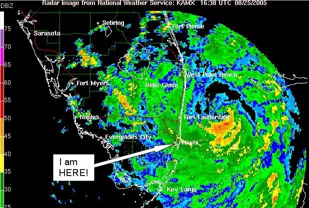
Not that it matters at this point. If you haven't left by now, you're pretty much on your own. You can either whole up in your house or office building, or head for the makeshift shelter in the Superdome. Either way you have to hope Katrina doesn't do a direct hit on the city.

I've been studying Superdome links (like here and here), but I can't determine if the building design will withstand a Category 5 hurricane. The wind braces described in the design sound reassuring, as well as the fact that its "the largest clear span steel structure in the world."

But if the water pours into the city in the midst of the hurricane, the flooding could trap the occupants inside. In a giant, dark, powerless room, holding over 100,000 people with exits designed for less than half that number, and a massive storm beating the building in around you, it sounds like a perfect recipe for a nightmare.

UPDATE:

Word came in that 'Poppy Z Brite' bugged out after all. Good. Although word is that he might have called it right anyway. Still can't be too careful.

Saturday, August 27, 2005

OH, NO.....
Just got word that Katrina has targeted New Orleans for her next landfall, and she's now a Category Five Hurricane.

This is serious.

A hurricane strike in New Orleans should be considered more serious than an earthquake in LA. New Orleans is below sea level. It is surrounded by dikes and levees, and requires massive pumps running constantly just to keep rainwater and groundwater out of the city. A breach in any of the levees should be considered a serious event. Hurricanes carve out channels in miles of land; cutting through a levee should be no big deal to a Cat 5. If that happens, with the storm surge New Orleans could see over 20 feet of water on Bourbon Street. Combined with high winds that would pretty much wipe out major portions of the city.

If you're reading this, and you live in New Orleans, don't take chances. Leave now.
AFTERMATH...
Katrina caught everybody by surprise: (1) As soon as it went ashore near Ft. Lauderdale it swept southward past Miami (and me); (2) It strengthened from a tropical storm to a Category One as soon as it came ashore - totally tossing out the rule that hurricanes start to dissipate when they hit land; (3) High speed wind bands accompanied the northern side of the hurricane, while massive rain came in on the southward side, drenching South Miami, Perrine, and Homestead with over 12 inches of rain overnight. And now (4) there's talk that Katrina is going to swing upward back into the Florida panhandle by Tuesday.

2 deaths reported so far, mostly by falling trees. If you don't have emergency power, well, you don't have power. Word is at least 800,000 are without power. Fortunately my hotel's emergency system worked well, and (as you can tell) Internet is still up.

My client's building has minor water damage, no power and lots of fallen trees. The signage at the top of the 9 story building has missing letters. Work crews are already here but have told me the building is closed. My company's office building was in similar shape.

All the traffic lights are out - fortunately there isn't a lot of traffic to worry about - yet.

Downed trees are everywhere. No stores are open and I know finding ice is going to be a critical concern for people here. It could take days to get power restored.

I was asked what was like to stand outside in 70 MPH winds. To be honest, I don't know. I stayed indoors.

They say there's a fine line between brilliance and insanity, and I prefer to think that I'm brilliant.

I have a few pictures and I'll try to post them soon. In the meantime I'm going to try to find an open restaurant.

Friday, August 26, 2005

KATRINA HURRICANE REPORT
I think the worst is past now. The hurricane actually took a dip southward toward Miami, and I think I literally went out to dinner during the eye of the storm, which was a little eerie. Winds mostly around 20-40 mph when I went out, with mostly drizzly rain.

Went under an overpass under construction on the way out; it collapsed about an hour later when the winds picked up behind me. CNN has the video.

At the restaurant you could hear the wind howling through the airducts - it was loud. When I first got there I couldn't open the door, and I thought the restaurant had closed, but it was the wind holding the doors shut.

On the way home it was dark, rainy, and still windy, with downed trees everywhere. I ran over an alligator in the road.

Really.

Yes, it was crossing the road and I didn't see him until I was right on top of him. About 4 feet long. I felt absolutely terrible - right up to the tree that had fallen across the road. I had to turn around, and face my handiwork.

But it wasn't there.

Maybe it was tougher than I thought (I am driving a pretty small car this week). Or maybe it had enough strength left just to get off the road. I don't know. I wasn't going to get out of the car to find out.

Had to take a few other detours to get out of the way of fallem trees. That must be how I got a nail in my right rear tire. Now I can say that I've changed a tire in a hurricane. My life is complete. While changing the tire in the driving rain I saw huge green flashes everywhere. Not lightning...transformers exploding, I'll bet. I've seen it happen before.

More updates as I think to add them.

Thursday, August 25, 2005

IT'S RAINING HORIZONTALLY NOW....
guess it's time to leave the office.
FORECAST FOR MIAMI: I'M GONNA GET DRENCHED...
Here is the latest view out of my office window, looking at Miami Airport:

Raining on and off right now, and the clouds are sweep north-to-south (left to right in the picture, as this is a NE view).


Fun fun fun. Maybe I'll wear a swimsuit to work tomorrow.